 The River to River Greenway travels 7.7 miles from the Lilydale trailhead of the Big Rivers Regional Trail (part of the Minnesota River Greenway) to Kaposia Landing and the Mississippi River Greenway. It goes through parks, residential and commercial areas in the communities of Mendota Heights, West St. Paul and South St. Paul.
 River to River Greenway Master Plan
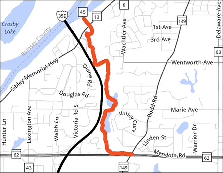
The planned project will construct and reconstruct portions of the 1.4-mile segment of the River to River Greenway between Dodd Road (Highway 149) and the Big Rivers Regional Trail in Mendota Heights. Dakota County will reconstruct about 1.4 miles of existing trail and construct a grade-separated tunnel of Dodd Road.
The finished greenway segment will consist of a 10-foot wide paved trail. Other amenities will include:
- Safety and accessibility improvements of the trail crossings of local streets
- Connections to local trails and sidewalks
- Seating
- Wayfinding and interpretive signage
- Landscaping
- Stabilization and stormwater improvements of Interstate Valley Creek
- Other features consistent with Dakota County Greenway Standards
The project received a $585,000 Clean Water Fund Grant. The grant is to stabilize and improve stormwater treatment at Interstate Valley Creek. This project will reduce stormwater volume, cut erosion and provide cleaner water. Read more about the project.
Construction schedule
May 16, 2025: Trail will reopen after Interstate Valley Creek work has been completed.
Aug. 1–November 2025: Trail will close again for trail construction and bridge replacement.
Summer 2026: Dodd Road–Marie Avenue closed for reconstruction.
River to River Greenway Project Map
Provide input
Sign up for project emails and give feedback
For assistance or more information
Stay up to date throughout the process by visiting this webpage. You can also contact the county's project manager if you have questions:
Mike Adams, Senior Project Manager
651-554-6538
mike.adams@co.dakota.mn.us