Turn on more accessible mode
Turn off more accessible mode
Skip Ribbon Commands
Turn off Animations
Turn on Animations
FollowFollow Focus on Content Focus on Content
Website input:
Help us make our website better. Give us your feedback in a short interview.
Dakota County Logo
  • Maps & Directions
  • |
  • Departments
  • |
  • About Us
  • |
  • Contact Us
Dakota County Logo
  • Government
      • Board of Commissioners
      • County Attorney
      • County Sheriff
      • Commissioner Meetings
      • County Manager
      • Budget & Financial Reports
      • Performance & Analysis
      • Land Use Planning
      • County Policies
      • Data Practices
      • Advisory Committees
      • Other Public Committees & Initiatives
      • Doing Business with the County
      • Information Technology
      • Grant Management
      • Jobs & Volunteering
      • Public Employee Training
      • Other Public Entities
      • Voting & Elections
  • Home & Property
      • Pay Property Taxes
      • Property Tax Statements
      • Property Tax 101
      • Property Tax Programs, Homesteads & Credits
      • Important Dates for Property Owners
      • Assessing Property
      • Recording Property Documents
      • Property Watch
      • Foreclosed Property
      • Tax-Forfeited Property
      • Online Property Maps
      • Online Property Records
      • Homebuyer & Homeowner Programs
      • Aggregate Tax
      • Evictions
      • Plats & Surveys
      • Taxing Districts & Tax Increment Financing
      • Selling Property
      • Maps & Mapping Services
  • Permits & Licenses
      • Service & License Centers
      • Birth Certificates
      • Death Certificates
      • Marriage Licenses & Certificates
      • Passports
      • Driver's License
      • Motor Vehicle Titles & Registration
      • Recreational Vehicle Licenses
      • Game & Fishing Licenses
      • Professional Licenses
      • Gambling Permits
      • Liquor Licenses
      • Cannabis Permits
      • Gun Permits
      • Assembly Licenses
      • Building & Land Use Permits
      • Business Hazardous Waste Licenses
      • Well Permits
      • Waste Hauler & Facilities Licenses
      • Highway Permits
  • Law & Justice
      • Most Wanted
      • Warrants
      • Criminal Complaint Search
      • Report a Crime Tip
      • Crime Prevention
      • Jail
      • Juvenile Detention
      • Crime Victim & Witness Support
      • Alternatives to Court
      • Service of Legal Documents
      • Law Library
      • Contact a Probation Officer
      • Probation & Community Programs
      • Conditions of Probation
      • Probation Fees & Restitution
      • District Courts
      • County Ordinances
      • Fingerprinting Services
      • County Attorney News Releases
      • County Sheriff News Releases
  • Health & Family
      • Healthy Living
      • Job Search Assistance
      • Parenting Help
      • Personal Finance
      • Public Assistance
      • Adult Protection
      • Child Care
      • Child Protection
      • Child Support
      • Adoption
      • Chemical Health
      • Foster Care
      • Mental Health
      • Aging & Disability Services
      • Emergency Preparedness
      • Health Services
      • Veterans Services
  • Environment
      • The Recycling Zone
      • Recycling Guide
      • Residential Recycling & Disposal
      • Business Recycling & Disposal
      • School Recycling & Disposal
      • Environmental Education Resources
      • Water Resources
      • Energy
      • Land Conservation
      • Sustainability
      • Environmental Funding
      • Environmental Reports & Studies
      • Report an Environmental Concern
  • Transportation
      • Current Road Construction
      • Planned Road Construction
      • Road Safety
      • Transportation Studies
      • Traffic Counts
      • Getting Around the County
      • Highways & Your Property
      • Transit
      • Contact Transportation
      • Transportation Planning
      • Sales & Use Tax
  • Maps & Directions About Us
    Departments Contact Us
Dakota County Home
Doing Business with the County
 
Search
  • Home
    • Transportation
      • Transportation Studies
        • Current Studies
          • Pages
            • pedestrian-crossing-safety-assessment

Contact

Transportation
952-891-7000
hwy@co.dakota.mn.us

  • Current Studies
    • County Road 33 Roundabout Feasibility Study
    • Cliff Road Study from Johnny Cake Ridge Road to Pilot Knob Road, Eagan
    • Pedestrian Crossing Safety AssessmentCurrently selected
    • Southview Boulevard Intersections (12th & 13th Avenues) Before & After Study
    • County Road 38 (McAndrews Road) Corridor Study from County Road 5 to Aldrich Avenue, Burnsville
    • County Road 31 (Denmark Avenue) and County Road 74 (220th Street W.) Corridor Study, Farmington
    • County Road 63 (Argenta Boulevard) and Interstate 494 Interchange Footprint Study, Inver Grove Heights
    • County Road 50 (Elm Street) Pedestrian Improvements from Division Street to Third Street, Farmington
    • Highway 3 Visioning Study
  • Past Studies

Pedestrian Crossing Safety Assessment

Page Content

​​​​​​Dakota County is conducting a pedestrian crossing assessment focused on side street stops and mid-block crossings of county roadways. The project will define best practices for review of crossings and treatments based on roadway conditions.

The project will review several crossing locations which represent a variety of conditions. The assessment will develop guidance for pedestrian crossings to improve safety throughout Dakota County.

The assessment will take place July through fall 2021.  A final report summarizing the process, including recommendations for the study locations, will be prepared following the review process.

Map of ​Intersection Crossings to be Reviewed

Crossing impro​vements and evaluation p​rocess

Dakota County, working with cities and our consulting team, developed recommendations for improvements at each location.

These improvements were developed based on federal and state guidance and will be installed to evaluate their effectiveness in improving pedestrian safety. 

In some instances, the construction for these improvements will be temporary.  This   approach is the most efficient, cost-effective way to complete evaluation and adjust as necessary. Following installation, county staff will evaluate the effectiveness of the improvement. Evaluation of the improvements will take 3–4 weeks.

Temporary improvements will be removed following the evaluation period. If the enhancement is proven to be beneficial a plan to permanently construct or install the improvement will be developed through the county's Capital Improvement Program.

For areas requiring more permane​nt construction work, this work will take place in 2022 or 2023, depending on work required.  If the enhancement is not providing benefit as expected, more review and recommendations will be made.

You can help us by taking our survey to let us know about your crossing experience.  Your feedback will give us the best information possible about the value of these improvements.​

Proposed intersections improvements

​Pedestrian Crossing Map

IntersectionCity
Tentative schedule ​Proposed improvement
Wentworth Avenue, County Road 8 and Humboldt Avenue 
West St. PaulInstalled
Wentworth Avenue Information Sheet
Southview Boulevard, County Road 14 and 12th Avenue
South St. PaulInstalled​
Southview Boulevard Information Sheet
Concord Boulevard, County Road 56 and 75th Street
Inver Grove HeightsWeek of Nov. 6
Concord Boulevard Information Sheet

Lexington Avenue, County Road 43 south of Northview Park RoadEaganNot applicable


Based on level of potential construction, interim improvements are not recommended as part of this assessment. Recommendation for this location will be summarized in the assessment report.

Pilot Knob Road, County Road 31 and Thomas Lake Park, High Line Trail

Eagan Not applicableNo interim action is proposed. Other similar locations statewide are being evaluated to help assess this location.
Dodd Boulevard, County Road 9 and the Lake Marion Greenway Trail (south of 207th street)
Lakeville Installed​
Dodd Boulevard Inform​ation Sheet
County Road 42, Nininger Road – crossing between Madison Street and Pleasant Drive​
HastingsNot applicable
Review determined a preliminary engineering assessment for the larger area from Riverdale Drive to Pine​ Street would be the most applicable approach,  study is listed in the Dakota County Capital Improvement P​rogram for 2022


​More information

The following links are resources regarding best practices for people crossing roadways as well as information about pedestrian crossing safety.

  • ​Minnesota Department of Transportation Pedestrian Safety Education 
  • U.S. Department of Transportation Pedestrian Safety

​Minnesota state law:

  • Minnesota Department of Public Safety​
  • Minnesota State Statute 169.21

​DIagram of a multiple threat situation described in text.​
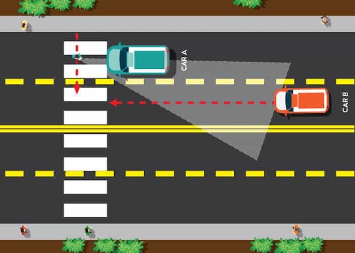
Multiple threat situation

​The multiple vehicle threat occurs for people crossing a roadway with two or more lanes going in the same directions. A vehicle in one lane stops for a person walking, rolling, or bicycling, and another vehicle approaching the crosswalk in the other lane. There is significant risk of a crash when the person crossing emerges in front of “Car B" after crossing in front of “Car A" as shown. This type of crash occurs because of both the person crossing and driving are unable to see one another. ​​


Last updated: 11/22/2022 10:45 AM

Administration Center
  • 1590 Highway 55
  • Hastings, MN 55033
  • Ph: 651-437-3191
  • Toll free: 800-247-1056
  •  
  • See all County buildings
    Social Media
  • Facebook
  • X
  • LinkedIn
  • Instagram
  • Youtube
  • Next Door
  • Sign up for E-News
    Quick Links
  • Home
  • Accessibility
  • Nondiscrimination
  • Language Translation
  • Job Opportunities
  • Make a Payment
  • Privacy Policy
Dakota County, Minnesota
Sign In